Hungry Mother State Park – Appalachia

Hungry Mother State Park

From I-85 N, we took Exit 47 at Marion, VA and followed the signage to Hungry Mother SP. The roads were easy to navigate to the first Park office at Camp Burson. Burson is below an earthen dam built by the CCC during the Depression, campsites are gravel or grass, some are shaded and there isn’t any cover between sites. At the office we were told that the other campground was up a “very windy road.”

Unhooking the car, it took only 15 minutes to explore the road, lake and Creekside Campground – the twists wouldn’t present a problem for the Trek. We signed in at the Discovery Center close to the main park amenities (boat ramp, canoe/kayak rentals, swimming beach, fishing pier, restaurant and bike/walking trail heads) and camped on Hungry Mother Creek.

Settled for a few days, we took a look at the things we could learn about this corner of Virginia.

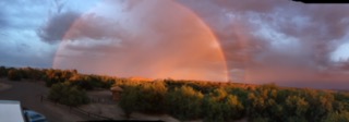
I’m starting to wonder about whether we travel under a weather curse. Rain. Everywhere we’ve been gray skies follow us. I appreciate the sun (read- worship) when it makes an appearance.

Hungry Mother Creek’s name has three possible origins, the most popular version begins with an attack on white settlers by “hostiles.” A whole village of people were killed and the women and children were taken captive. Among those were Molly Marley and her two year old daughter.

Legend has it that Molly and her child escaped and wandered the forests eating berries. Molly finally collapsed and the child wandered down the creek until she was found. The child uttered two words, “Hungry mother.” Molly died and nothing more is said about her little girl but the two words were branded to the creek and when the impoundment was created, the lake and park got the same name.

We walked the park and explored Marion. There are a couple of good places to eat – The Wooden Pickle Bar and Grill was closed when we stopped by but we got two enormous sandwiches at Macado’s (Mack-a-Do’s). The interior of the restaurant is crammed with movie and baseball memorabilia. We each took half a sammie home and had two ‘normal’ sized sandwiches the next day. I meant enormous!

One of our explorations found us driving the famous Dragon’s Backbone – CR16. Famous because of the twists and hairpin turns that motorcyclists love. “Dragon’s how Backbone for some knee-dragging fun!” boasted a brochure at the park’s Discovery Center. It was a fun drive and passed a rainy day nicely.

We also explored Saltville, chiefly through the eyes of the Museum of the Middle Appalachians. The museum is small and powerfully curated. From the Pleistocene times (mammoth teeth and bones) to the 1960’s, the museum’s collection offered insight into life and times.

The museum has a notable collection of early Native American jewelry in the form of shell bead strings – one is forty-two feet long – and arrowheads.

Around the tops of the walls were core samples of earth pacing a timeline with adjoining displays. Saltville was founded before the Civil War by folks who wished to exploit the rich salt deposits 200’ deep in the earth. The mines are located in the valley and the workers houses, company store and school were all on the hillsides around the mines.

The first attempts to extract the salt followed traditional mining – drill a hole, widen it and bring up the salt. That failed because Appalachia is water country. If there is a seam in the ground, water seems to seep or run out of it and sure enough, ground water went right into that first mine. The water set the method of mining, saltwater was pumped to the surface, evaporated in kettles (that look just like sugar kettles in south Alabama). The evaporated sale would then be scraped out and bagged.

During the Civil War salt from Saltville mines played an important part in food and the manufacturing of munitions. During the Civil War, each southern state had it’s own mine and evaporator. Evidence of Alabama and Georgia’s mines are still visible near the ponds that grace the landscape today.

Saltville was a company town, workers could receive script valued at $1.10 or cash at $1.00. Script from the Mathieson Company had such good value that people could go south to the big town of Buckley and spend or cash it out in most of the stores. The town boasted the best high school science program in VA until it was closed in the 1960’s.

Our docent went to that school and was later told, by her college science instructor, that she had a significant advantage over other students. She also described being a child in Saltville, the parades and semi-pro baseball team, the sense of intimacy and knowing everyone, the safety and beauty that surrounded the people who lived and worked in Saltville. She was of the first generation to need to move away to find work and one of many who returned to retire.

I read a local newspaper while we were in Marion. The focus of most of the articles was environmental pollution and how it affects the local population. The number of mines (of nearly all exploitable minerals) in Virginia and West Virginia that have been abandoned is staggering. Those mines, being in Appalachian Water Country, seep their minerals into peoples wells and the springs that many folks drink from.

Chemical companies still rule employment in the area. One local company that legally dumps the chemical PFOA into the New River admits to no wrongdoing while it supplies hundreds of residents with bottled drinking water. Don’t take my word for it, look up some of the towns in Appalachia and find out about land and water issues folks face.

Inroads were made on cleanup of mines and chemicals in water supplies but I wonder how much more cleanup money or government holding corporate polluter’s feet to the fire will occur since the current administration is repealing rules and regulations of the Clean Air and Water Act left and right.


To the Great Smokey Mountains

April 19 – 22, 2018

Black Rock Mountain State Park, GA

Up we climbed on a narrow two lane road, following signs, not knowing what to expect. This may seem an innocuous statement, but climbing a thin strip of blacktop in a 28’ motorhome while pulling a car is no laughing matter. One, we can’t back up while the car is attached to the coach. Two, the coach is eight feet wide. And three, tight blind curves are disconcerting! Honk-honk!

At the top we found a gentle dome about 500’ wide. Barb backed the RV in to a spot on the West side of the dome. We had inadvertently put ourselves right on the crest of the Continental Divide!

When we turned off SR23, we had no idea we were climbing the highest mountain in Georgia – 3640’. The park offers 1700 steep acres that include the Continental Divide and part of the Appalachian Trail. We hiked for a couple of hours around the side of the mountain, over the divide and back, and on the ridge line, part of the Continental Divide.

I remember the first time I was on one of these geographic delineations. My dad, sister, Barb and three of our children made an extended fishing trip across the Northwest and into Canada near Banff. My dad talked about the Divide and how the waters flowing from mountains there went to one side or the other – east or west.

While we were at Black Rock, a water leak up hill from our site had water running down to our spot on the dome. It didn’t make it far enough to have to choose which side to go down. It, like the glass of water I poured out to test the divide, simply soaked in and disappeared.

This is a great park but not for the faint of heart towing or Coaching. There are only 38 mixed use campsites and some aren’t very level at all. Still, the hiking was wonderful, photo views plentiful and the black rocks at the summit of the trail are pretty.

Great Smokey Mountains National Park

The drive to Cosby Campground in the GSMNP took us around the park to the Northeast side. From Black Rock Mountain State Park in Georgia we followed SR 23-441 over to I-40 and north. The trip became interesting after taking Exit 447.

From this campsite in Cosby Campground inside the National Park, I advise anyone towing or driving an RV, do not look at GPS or Maps to get you over to CR 32. In fact I’d venture, don’t take exit 447. We admit, we do like to use Maps (iPhone) and Google Maps.

Our GPS took us down a wide one lane road which we finally, shared with a school bus. We stopped and asked the driver about the road. She shared that the way we were heading led to a more narrow road but that it would indeed get us up to 32. She advised taking it slow because we’d be going past folks houses and she’d been depositing children along the way.

We did exactly as she said and arrived at 32, by then the GPS had abandoned all hope. The voice wanted to re-route in a circle, every few feet we rolled forward ‘she’ freaked out. You know when that happens?

Cosby campground sounded pretty good, when we saw the sign. Phew!

The campground itself is graveled, RV sites are paved and vary as to their flatness. We tried one site, gave up when we couldn’t level and moved to another. There isn’t any cover between sites at all and the RV sites, at least, are packed pretty tightly – the play-doh the kids at the next site use is brand x, for instance. This is a good place from which to hike or drive out to explore the park.

I made Andouille Sausage and shrimp with veggies and quinoa for a spicy good Gulf style dinner. The recipe is from Cooking Light magazine, always reliable for simple, tasty meals. During the night it got cold enough that Rudy (the handsome silver-gray old meow of our tribe) climbed under the covers!

We woke to a bit of a calamity. Dasher (the young, destructive, butter-gold newest meowster of the tribe) amused himself during the night by chewing up one of my new hearing aid ear molds. Luckily, he didn’t damage the BTE part the mold plugs into.

I always take my old HAs along when traveling, so I can use them and I am grateful for that. The new HAs are so technologically advanced that to compare the old with the new is to compare an iPhone 8 with a 20# black rotary dial phone. They make 150 decisions a second to adjust to my hearing environment, the experience is gorgeous.

Gatlinburg is thirty minutes away from Cosby Campground and there are lots and lots of RV parks, RV Resorts and cabins for rent as you head through to the GSMNP Visitor’s Center. Those choosing to stay in them pay a premium for hook-ups and summer time amenities like swimming pools.

We drove to the Visitor’s Center and enjoyed the ubiquitous movie and displays of preserved plants and creatures that once lived wild. We also called Candace, my audiologist. In about two weeks, I should have a new ear mold. We’ll figure out where to have it sent as we get closer to the date. What a relief!

After exploring the Visitors Center and identifying a this flower we saw at Black Rock Mountain SP, we headed up to Chimney Rocks picnic area for lunch. Running beside the picnic areas is a gorgeous trout stream. After lunch we walked along the water – staying to trails and being conscious of not stepping on any uniquely biodiverse plant life.

The park has 2,115 miles of streams in it’s boundaries and is one of the last wild trout habitats in the eastern US. Though acid rain from nearby coal and manufacturing plants damaged the waterways and affected the health of trout the park has seen steady improvement since the Clean Air Act went into effect. Note: the administration has recently seen fit to repeal the Clean Air and Water Act so expect continuing damage from human short sightedness.

The thousands of streams, brooks and trickles that contribute to the rich diversity of plant and animal life here in the park:

Five separate riparian zones host 1,500 flowering plants, dozens of native fish, over 200 species of birds and 60 of mammals.

The park is Salamander Central with more species of salamanders concentrated in one area than anywhere else on earth. Thirty species live in the park and 24 of them are lungless. Some exist only in GSMNP.

The smoke in the Smokies is a misty fog that rises from all the moisture in the mountains.

Lastly, elevations in the park climb from 660’ to 6500’ and the Appalachian Trail wends it’s way through the parks length. We did a cameo appearance, walk on walk off, on AT just to say we did it, but I think it might be fun to take on a section here in the park someday. Turns out that most of the flowing water in the park originates up on the crest of the Smokies along the Trail.

Some of the people who have used the 848 miles of trails in the park have paused to deface trail signs and shelters with graffiti and leaving behind their trash. 1,500 lbs of trash were hauled out of backcountry campsites and shelters in 2017. Is there a lack of awareness and education or are some people simply mean and destructive?

Today, Saturday, is a writing, meditating and cleaning day for your travelers. We walked a nice one mile trail, leaving behind nothing but footprints and taking lots of photos of flower carpeted glades and streams. We’ve seen a few new (to the trip) birds here in the park – the American Turkey, Blackburnian Warbler, Northern Parula, Black Throated Green Warbler and the Blue Headed Vireo were standouts.

Both of us were enamored of the streams and trickles that appeared around every bend. The Great Smokey Mountains National Park is a wonder and worthy of a visit.

Here’s food for thought. The folks in the space next to us ran their generator, which sat in the back of a pickup truck, from 9 am to 7 pm on Saturday. They seemed to stay inside their pop-up camper and watched a huge screen tv. We went hiking to escape.
A few other campers thought it was our generator and had to be disabused of that thought. When the generator people turned the thing off, they hopped into their trucks and left the pop-up. I never did that type of camping and just don’t understand what the appeal would be. Surely, it’s much easier to stay home?

I just opened Pandora’s Box. The type of travel camping we do really isn’t camping, either. I’ve heard it called “Glamping” which makes me think of forty-five foot rigs that must be plugged to a fifty amp nipple or their residential refrigerators won’t run. That’s not what we do either.

In motorhome and towable land, we’re small. We hold a high standard of Camping Etiquette – footprints left behind, campsite cleaner than we found it, maintain quiet, be respectful of other folks, pets leashed etc.. We don’t run our generator longer than necessary and even then we wait for folks around us to leave when possible.

We sure aren’t ‘roughing it’ tenting or tear dropping though. Our RV is filled with luxuries – it even has an in house vacuum, for crying out loud. I don’t know what to call our style. Ideas anyone?

For now enough about defining our type of travel. Barb and I started RVing together in 1994 and purchased our first Safari Trek in 1995. I don’t guess we’ll change how we go after all this time.


Thank you for waiting:

Here we go! It’s April already, 2018 and we’re making tracks again. Hope you can come along for the ride.

Last week we devoted ourselves to tying up loose ends and finalizing the planning for this trip. The route we will travel is pretty much planned, we know where we’ll be stopping for nights and for sights and have lists of bike trips, hiking, museum-ing, learning and visiting goals.

Our 2017 traveling, taught me (Liz) something about food storage and I hope to have implemented enough changes that we won’t have to shop quite as often. For instance, we eat tons of veggies and fruits. The little bins at the bottom of our Norcold fridge proved to be inadequate. I got a couple of plastic boxes that fit the shelf above the little bins and they are now filled with the overflow produce we will eat this week. I also froze some favorite foods we won’t find once we leave the South (Gulf Shrimp, for sure!).

We will be holding a north-easterly heading all the way to the Catskills in New York. First big camp, the Great Smokey Mountains National Park. We hope the weather holds and it isn’t too cold up there. In fact, that’s my wish for this whole trip – that it not be too cold. Even where we live, it has been a long cold spring.

Barb and I have a Fly Fishing class – 6 days – in the Catskills in upper New York State in early May. We are both looking forward to learning more and getting in some practice in the storied waters that hosted the very start of the sport. The class is one of Road Scholar’s offerings, Elderhostel’s new brand. RS caters to traveling learners who are over 50 years old.

Last spring, we went to RS Summer Camp. It was held in Arkansas at Trout Lodge, a beautiful YMCA camp on a lake. Did we have fun! It was so much like camp when I was a girl, there were kids everywhere – all thoroughly engaged in the activities du jour, laughter and kids shouts from the lake or the trails across the conifer shrouded hills. It was fabulous. We over-50 campers enjoyed canoeing, kayaking, sailing, hiking, zip-lining, tower climbing, target shooting, crafts, horseback riding and a locked room challenge; seriously it was the best camp experience ever!

Today we camp in Georgia at an Army Corps of Engineers campground in West Point, Georgia. We both look forward to a walk on whatever trails or roads the campground offers, to shake off the road – if we get there in time.

I feel right at home as we take the exit from 85, this is the same exit we took around St. Patrick’s Day to spend a long weekend at a (very expensive) RV Park with the Heart of Dixie Chapter of RVing Women. We visited Calloway Gardens and Roosevelt’s Little White House and met some really nice gals. Franklin Roosevelt loved this part of Georgia and came here for healing waters treatment. We agree with him, this is a gorgeous part of the US!

Back to the present though. R. Shaefer Heard Army Corps of Engineers Campground is on West Point Lake – technically the West Point Project water resource management area. This campground is an easy 6 or so miles off I-85 N.

What a place – waterfront property today for these girls! The entire door side of the RV faces the water, we have a deck and stairs leading to the water where we could tie our boat up to a tree.

The campground is really large, 117 sites and all are reservable. On our walk, we found many campsites clustered together for families and groups. Eleven pull-through sites (one of which we occupy) make it easy for folks who are passing through or aren’t good at backing into sites. Most of the campsites are right on the lake, many are surrounded by trees and bushes that make them very private. This month, the campground isn’t full at all. One thing to note; there appears to be one shower building but most of the small tan buildings hold sinks and toilets.

After the hot drive on 65 and 85, fresh breezes coming off the lake are welcome. The campsite is busy with Yellow-Rumped Warblers, Palm Warblers, Chickadees, Eastern Bluebirds and Carolina Wrens. We hear a woodpecker working for dinner and the shushing of the tiny red waves rushing toward our shore. Red waves because this is Georgia, red dirt reigns.

4-18

Leaving the lake side window shades up all night afforded us a rare treat, a view of the lake as we woke with the light. Lake water moves in a most mesmerizing fashion, she says after falling back to sleep.

Another thing learned; long drives are exhausting. We decided to drive shorter distances and spend more of each day out of the RV during this eastern US sojourn.

The plan is to make a short trip (under 3.5 hours driving) to the next overnight.  We’re zooming along on 985 N right now. Barb just suggested we keep going for another hour to Black Rock State Park closer to the Smokeys… I’ll let you know how the longer drive today meets out goal to drive shorter distances.

We’re glad to be traveling again.  Please leave comments for us and don’t forget to hit the follow button!

Breathe.